


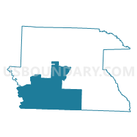
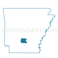
Voting District 8, Dallas County, Arkansas
About
Outline

Summary
| Unique Area Identifier | 526375 |
| Name | Voting District 8 |
| County | Dallas County |
| State | Arkansas |
| Area (square miles) | 157.46 |
| Land Area (square miles) | 157.14 |
| Water Area (square miles) | 0.32 |
| % of Land Area | 99.79 |
| % of Water Area | 0.21 |
| Latitude of the Internal Point | 33.88375730 |
| Longtitude of the Internal Point | -92.73845770 |
Maps

Graphs
Select a template below for downloading or customizing gragh for Voting District 8, Dallas County, Arkansas


Neighbors
Neighoring Voting District (by Name) Neighboring Voting District on the Map
- Voting District 6, Dallas County, AR
- Voting District 7, Dallas County, AR
- Voting District 9, Dallas County, AR
- Carroll Voting District, Ouachita County, AR
- Curtis Voting District, Clark County, AR
- Freeo Voting District, Ouachita County, AR
- Union Voting District, Ouachita County, AR
Top 10 Neighboring County Subdivision (by Population) Neighboring County Subdivision on the Map
- Caddo township, Clark County, AR (22,995)
- Union township, Ouachita County, AR (1,385)
- Owen township, Dallas County, AR (908)
- Freeo township, Ouachita County, AR (401)
- Holly Springs township, Dallas County, AR (314)
- Carroll township, Ouachita County, AR (258)
- Jackson township, Dallas County, AR (190)
- Princeton township, Dallas County, AR (152)
- Nix township, Dallas County, AR (117)
- Liberty township, Dallas County, AR (32)
Top 10 Neighboring Place (by Population) Neighboring Place on the Map
Top 10 Neighboring Unified School District (by Population) Neighboring Unified School District on the Map
- Fordyce School District, AR (5,722)
- Harmony Grove School District, AR (5,284)
- Gurdon School District, AR (4,430)
- Bearden School District, AR (3,480)
Top 10 Neighboring State Legislative District Lower Chamber (by Population) Neighboring State Legislative District Lower Chamber on the Map
- State House District 19, AR (27,250)
- State House District 20, AR (26,358)
- State House District 5, AR (22,892)
Top 10 Neighboring State Legislative District Upper Chamber (by Population) Neighboring State Legislative District Upper Chamber on the Map
Top 10 Neighboring 111th Congressional District (by Population) Neighboring 111th Congressional District on the Map
Top 10 Neighboring Census Tract (by Population) Neighboring Census Tract on the Map
- Census Tract 9501, Ouachita County, AR (5,686)
- Census Tract 9539, Clark County, AR (5,472)
- Census Tract 9702, Dallas County, AR (1,887)
- Census Tract 9701, Dallas County, AR (1,564)
Top 10 Neighboring 5-Digit ZIP Code Tabulation Area (by Population) Neighboring 5-Digit ZIP Code Tabulation Area on the Map
- 71701, AR (20,286)
- 71923, AR (15,637)
- 71742, AR (5,980)
- 71720, AR (2,498)
- 71763, AR (1,666)
- 71725, AR (555)